
Adventures in the Archives: Shucking at the Knobbs
by Ashley Adams Serveiss, Collections Manager & Archivist
For a small barrier island roughly 11 miles in length, Plum Island packs in a lot for its size. Protecting the marshlands of Newburyport, Newbury, Rowley, and Ipswich from the Mighty Atlantic, Plum Island has played host to a wide range of residents and industries over the course of its history. In 1845, local historian Joshua Coffin wrote, “Plum Island, a wild and fantastical sand beach, is thrown up by the joint power of winds and waves into the thousand wanton figures of a snow drift.” (Coffin, Joshua. 1845. Sketch of the History of Newbury, Newburyport, and West Newbury, from 1635 To 1845).
In the last few weeks, our Executive Director, Bethany Groff Dorau, has given two impressive talks on the “wild and fantastical” island we all know and love. Today, I am returning to Plum Island (metaphorically, of course), to some shed light on one of the long-gone places on Plum Island, the Knobbs. Before I get to the Knobbs, however, I think it practical to give an extremely condensed history of Plum Island, for a bit of context.
For thousands of years prior to European settlement, the Agawam, an Algonquian people, frequented the island during the warm summer months. The Agawam likely used the island as a seasonal camp and spent their time hunting and fishing. Unfortunately the large majority of the Agawam People were taken by an early smallpox epidemic in 1617; the remaining few later assimilated. After this, the early European settlers began grazing cattle on Plum Island and harvested salt marsh hay, which was used for livestock feed, bedding, and building — in the 17th century, the land was held in Common by the Freeholders. Pine trees, which no doubt once existed on Plum Island en masse, were cut for lumber and floated to Port. In the 18th century, a hospital, called the Pest House, was built at the northern end of the island to deal with smallpox outbreaks. Forts were built during this time, along with two lighthouses and a scattering of makeshift shelters for stranded sailors whose ships wrecked near the bars.
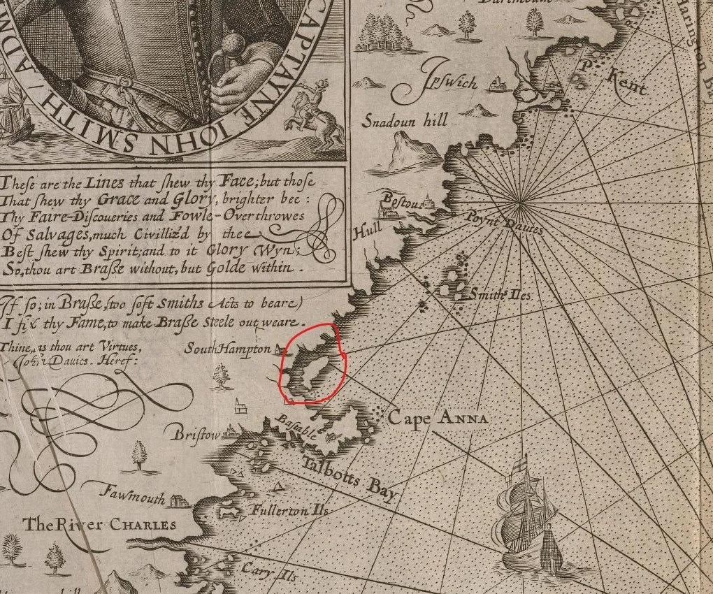
Captain John Smith's 1616 map, in which he named New England. "Cape Anna,” or Cape Ann, is clearly marked. I crudely circled what we assume must be Plum Island, to the north of Cape Ann. The island appears much larger than it actually is. To the north are the “Smith Iles,” known today as the Isles of Shoals.
By the 19th century, development on the Island began to take hold. The Plum Island Turnpike was built, along with the bridge over the Plum Island River. The Plum Island Hotel, which I wrote about several weeks ago, attracted pleasure seekers and sportsmen alike to the island. A saltworks was constructed at the southern end of the island in the 1820s. Cottages began appearing towards the end of the century, mostly on the northern end. By the early 20th century, the island had a dance hall, billiards hall, street trolley service, and plenty of seasonal and year-round cottages for the area’s beach lovers.
In the latter 19th century, a lifesaving station was built roughly 2 miles from Sandy Point, at a place called Knobbs Beach, on the eastern side of Plum Island. On the western side, right about where Parking Lot 5 currently exists within the Parker River National Wildlife Refuge, was the location of “The Knobbs.” Nobody really knows how the area got its name — I poured through Nancy Rodigrass Weare’s book, Plum Island: The Way It Was, along with Coffin’s history and a few other resources we have here in the Archives, to no avail. The Knobbs appears to have been the only sandy stretch of beach on an otherwise marshy western side of Plum Island. What piqued my interest in The Knobbs (which I admittedly had never heard of before) was a photograph recently processed by one of our summer interns, Eliza Brennan.
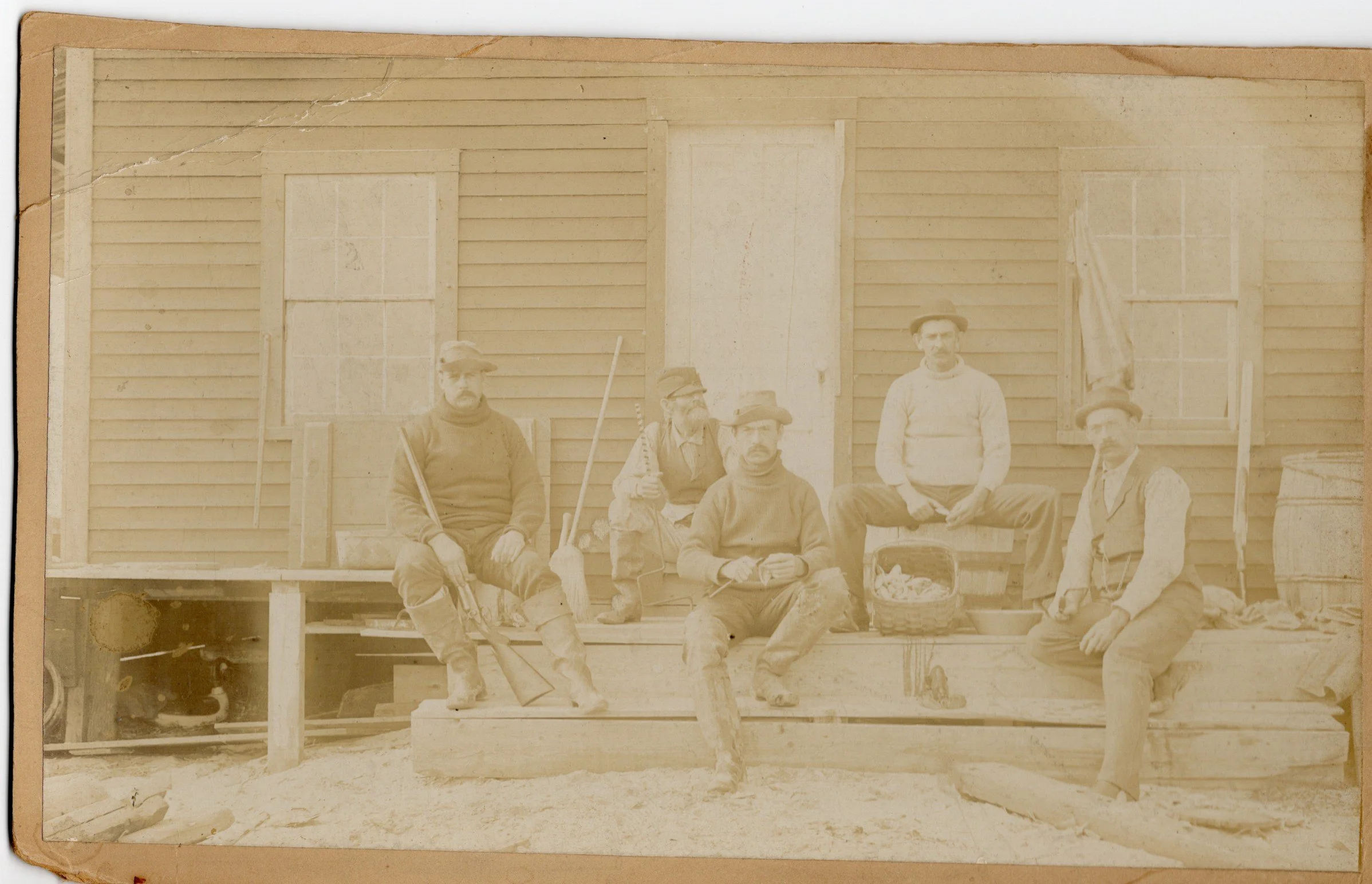
Late 19th century photograph of five sportsmen at the Rodigrass Camp at the Knobbs on Plum Island. Image is GPH-4 from our General Photograph Collection. Many thanks to Intern Eliza Brennan for cataloging this historic image.
The photo shows a group of men posing with their firearms and shucking what are likely clams. A note on the verso says the image was taken at the, “Rodigrass Camp at the Knobbs, Plum Island.” I found little about the camp, only that it was a hunting camp built around 1882 by Nathan Rodigrass, no doubt a relative of Nancy Rodigrass Weare. As an aside, we recently acquired the papers of Nancy Rodigrass Weare, and I am sure there will be another Adventures in the Archives to cover that collection, too!
From what I could gather, the Rodigrass Camp at the Knobbs attracted duck hunters and other sportsmen to Plum Island’s southerly end. The camp itself appears to have remained standing until 1899, when it was eventually torn down. The Knobbs, and the Rodigrass Camp, later became home to Camp Seahaven in 1947. Founded by Daniel R. Harrington Sr., a polio survivor, the camp functioned as a convalescent space for children recovering from polio until the 1970s, when it became a space for those with cerebral palsy. In 1988, the camp closed for good, and the area was taken over by the Parker River National Wildlife Refuge. The last remaining buildings were torn down, and now the area is one of the most beautiful parts of our beloved Plum Island.